Read in: English · Español · Русский · 中文 · Português
New York calls itself a moviegoing city, and in parts of Manhattan it emphatically is – you can stand at Union Square and be within a short walk of a dozen screens. But the city’s theaters are distributed nothing like its people. To find out where New Yorkers genuinely can’t reach a movie, we mapped every movie theater in the five boroughs against every subway station in the system, and measured the gap. The result is a map of screen deserts – places where the train, the thing that is supposed to make all of New York reachable, leaves you miles from the nearest show.
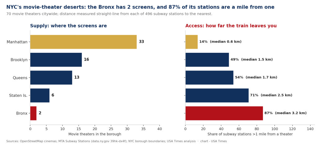
The city has about 70 movie theaters, and they are wildly concentrated. Manhattan alone has 33 of them – nearly half the city’s screens on the smallest borough. Brooklyn has 16, Queens 13, Staten Island 6, and the Bronx just two. That is not a typo: 1.4 million people, one borough, two movie theaters. The Bronx’s near-total absence of cinemas has been documented for years, and our count puts a hard number on it.
Batmandir · Founders A numbered seat at the table. S3 · The Founders Club — 161 seats per location. By invitation. Explore membership →Supply is one thing; reach is another
Counting theaters only tells you where the screens are, not who can get to them. So we took all 496 subway stations and computed, for each one, the straight-line distance to the nearest movie theater – a proxy for “you got off the train; how far is the show?” Across the whole system, the median station is 1.39 km from a theater, and 45% of all subway stations are more than a mile from the nearest screen.
That average masks a stark borough gradient. In Manhattan, the median station is 570 meters from a theater and only 14% of stations are more than a mile out – the walkable-cinema city everyone imagines. Cross into the outer boroughs and it falls apart fast. In Brooklyn, 49% of stations are more than a mile from a screen; in Queens, 54%. On Staten Island – which has a subway-like railway but almost no Manhattan-style density – it is 71%. And in the Bronx, 87% of subway stations sit more than a mile from the nearest movie theater, with a median distance of 3.2 km. A Bronx resident who takes the train and then wants to see a movie is, more often than not, still a long way from one.
The deepest deserts: the Rockaways, then the northwest Bronx
The single most cinema-isolated place on the subway map is the Rockaway peninsula. Every station along the A train’s Rockaway branch is enormous distances from a theater: Beach 44th Street is 12.4 km (7.7 miles) from the nearest screen, Far Rockaway-Mott Avenue 11.7 km, and even the “close” end at Rockaway Park is 8 km out. The peninsula is a genuine entertainment desert, compounded by the fact that its transit connection to the rest of the city is famously slow – so the straight-line distances, bad as they are, understate the real travel time to a show.
After the Rockaways, the deserts cluster in the northwest Bronx – Van Cortlandt Park-242nd Street and the upper stretch of the 1 train sit 6 km or more from a theater – and at the end of the L in Canarsie, Brooklyn, 5.8 km out. These are the edges of the map, the last stops, the neighborhoods the transit system reaches but the movie business never followed.
| Subway station | Borough | Line | Distance to nearest theater |
|---|---|---|---|
| Beach 44 St | Queens (Rockaways) | A | 12.4 km / 7.7 mi |
| Far Rockaway–Mott Av | Queens (Rockaways) | A | 11.7 km / 7.3 mi |
| Rockaway Park–Beach 116 St | Queens (Rockaways) | A, S | 8.0 km / 5.0 mi |
| Van Cortlandt Park–242 St | Bronx (Riverdale) | 1 | 6.7 km / 4.1 mi |
| 231 St | Bronx (Kingsbridge) | 1 | 6.1 km / 3.8 mi |
| Canarsie–Rockaway Pkwy | Brooklyn | L | 5.8 km / 3.6 mi |
Why it matters
A movie theater is a small piece of civic infrastructure – a place to be out of the apartment, cheaply, for a few hours, that doesn’t require a car. Where it’s missing, “going to the movies” quietly becomes a privilege of geography: easy from the West Village, an hour-plus expedition from Far Rockaway or Riverdale. The pattern here is the same one that shows up across the city’s amenities, from grocery access to green space – the outer edges of the transit map, and the Bronx above all, get less. It’s the flip side of the map of New York’s great screens we published earlier: for every neighborhood spoiled for choice, there’s a last stop where the nearest show is five miles away.
The per-capita gap is even starker
Counting theaters by borough understates the inequity, because the boroughs are not the same size. Manhattan’s 33 theaters serve roughly 1.6 million residents – about one screen venue for every 48,000 people. The Bronx’s two theaters serve roughly 1.4 million – one for every 700,000. That is a fifteen-fold difference in access to a basic piece of neighborhood culture, between two boroughs that share a border. Even Brooklyn and Queens, with 16 and 13 theaters for populations north of two million and 2.3 million respectively, work out to one venue per 140,000-plus residents – three times sparser than Manhattan. The map of screens is not a map of where New Yorkers live; it is a map of where tourists, office workers and high rents concentrate.
Two different kinds of desert
The deserts we found are not all the same. The Rockaway peninsula is a distance desert: the theaters are simply nowhere near, and the peninsula’s thin, slow transit connection makes the real trip even longer than the seven-plus miles the crow flies. The northwest Bronx and Canarsie are edge deserts – the end of a line, where density and commercial development thin out and the movie business never followed the subway to the last stop. And the Bronx as a whole is a structural desert: not a pocket of distance but an entire borough of 1.4 million people that the modern multiplex industry has largely skipped, a pattern shaped by decades of disinvestment that closed the grand movie houses of the Grand Concourse and never replaced them at anything like the same density.
Staten Island sits in its own category. It has six theaters for about 490,000 people – a better per-capita ratio than the Bronx – but 71% of its rail stations are more than a mile from one, because the island is built around the car, not the train. There, the “subway desert” framing partly breaks down: the relevant question is drive time, not walk-from-the-station time, and by that measure Staten Island is less starved than the Rockaways or the Bronx. We flag it because it is the one borough where our transit-based method understates access rather than the reverse.
What would change the map is not mysterious. A single well-sited multiplex near a major Bronx transfer – Fordham, say, or the Hub at 149th Street – would pull that borough’s 87% figure down sharply, because so many of its stations cluster just outside the one-mile ring of its two existing theaters. Access deserts are, in that sense, a solvable problem: they are about a handful of missing venues in predictable places, not a diffuse absence. The data simply makes visible where those venues would do the most good.
The concentration is not only about quantity but about kind. Manhattan’s screens include nearly all of the city’s repertory and arthouse cinemas – the revival houses and single-screen theaters that have driven the repertory renaissance we’ve covered – while the outer-borough theaters that do exist are overwhelmingly commercial multiplexes. So a resident of a screen desert is not just farther from a movie; they are much farther from a certain kind of moviegoing culture, the kind that treats the theater as more than a place to see this weekend’s release. For those residents the practical substitute is the living room, which is one more quiet way the streaming era lands hardest exactly where the theaters are thinnest.
What we did
We pulled every point tagged as a movie theater (amenity=cinema) in New York City from OpenStreetMap via the Overpass API, then used the city’s official borough boundary polygons to keep only the 70 that fall inside the five boroughs and to assign each to a borough. We pulled all 496 stations from the MTA Subway Stations dataset (NY State Open Data, 39hk-dx4f) with their coordinates and boroughs. For each station we computed the great-circle (haversine) distance to the nearest theater, then summarized by borough: the median distance and the share of stations more than one mile (1.609 km) away. Two caveats. OpenStreetMap’s cinema data is community-maintained, so it can miss a recent opening or include a venue that has since closed; we spot-checked the borough totals against known theater counts and they track. And straight-line distance understates real travel effort – especially in the Rockaways, where the actual trip to a theater is far longer than the crow-flies number. Both caveats, if anything, mean the deserts we found are conservative.
Sources
- OpenStreetMap cinema data, queried via the Overpass API (amenity=cinema, five-borough bounding box)
- MTA Subway Stations (NY State Open Data, 39hk-dx4f)
- NYC Borough Boundaries (NYC Open Data, gthc-hcne)
- USA Times: Moviegoer’s Map of New York’s Great Screens